The most effective real estate flyers often feature meticulously crafted real estate maps. Whether you’re a seasoned real estate agent aiming to boost sales or a print designer specializing in real estate marketing, your goal is to craft captivating real estate exposés and flyers that both attract and inform potential buyers. This is where Printmaps comes in. Our map editor empowers you to effortlessly customize maps, enhancing your open house invitations, market updates, just sold announcements, and new listings flyers.
Discover the extensive features of the Printmaps editor to unlock its full potential for your real estate marketing endeavors!
The Role of Maps in Real Estate Flyers
In today’s real estate landscape, flyers and exposés remain potent tools for showcasing open houses, market reports, and past sales. They offer a prime opportunity to directly present your brand through high-quality photographs, consistent use of brand colors, and, notably, personalized real estate maps.
With Printmaps, you can download high-resolution maps of any location at 300 dpi and incorporate essential points of interest within the neighborhoods. This guarantees that the quality of the maps remains uncompromised when utilized in print for your real estate flyers or real estate exposés.
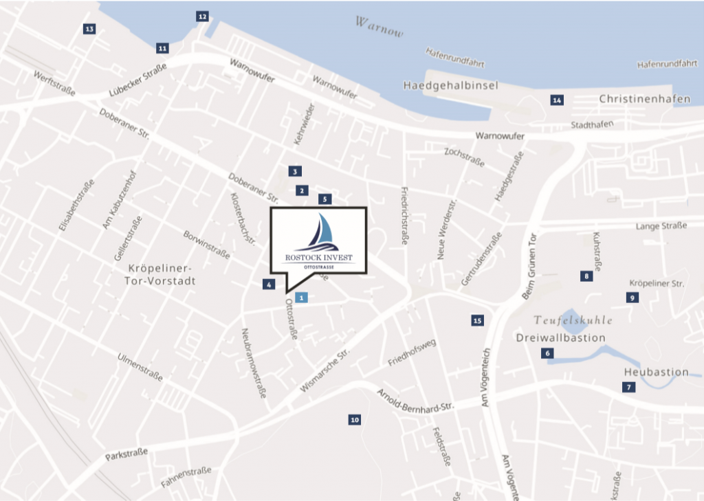
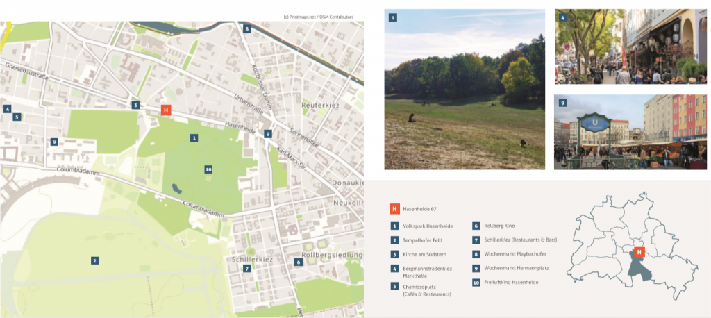
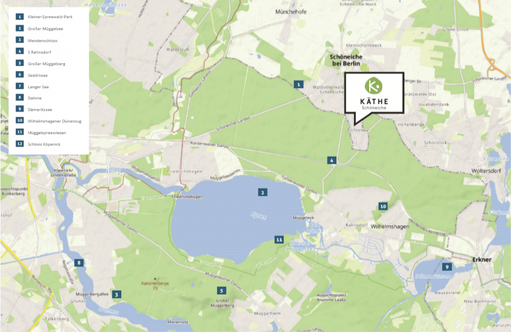
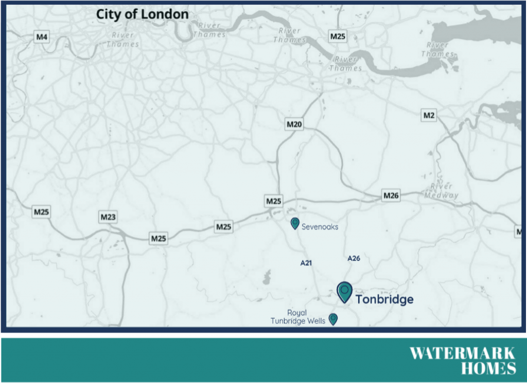
Real Estate flyers examples with maps
For real estate flyers, brochures, or property descriptions, it’s crucial that the map images are high resolution. This ensures clarity and prevents the printing of pixelated maps. When optimizing your Real Estate flyers, the strategic use of words like “luxurious” can significantly enhance sale prices. Naturally, you wouldn’t want to compromise the value of your luxury real estate flyers with low-quality images.
The importance of maps in real estate flyers
Real estate maps are an irreplaceable part of real estate marketing. People in search of a new home are curious to find out about the surroundings of their potential new house. Examples of what they want to know are: Is there a good school nearby where their children can go, a park to walk their dog and what restaurants are in the neighbourhood? What is the closest hospital? How is the road network? Can they easily reach their work? If you want to make great real estate flyers, it is very important to map the environment.
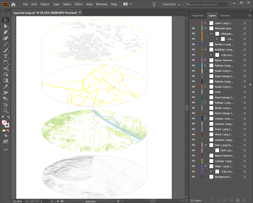
Endless creativity while editing in Illustrator or Photoshop
When aiming for truly exceptional and attention-grabbing creative real estate flyers, opting for a standard format chosen by your competitors won’t cut it. You’re likely already utilizing editing tools like Illustrator or Photoshop. With Printmaps, you can effortlessly download a layered PSD or SVG file, which you can then open in Illustrator or Photoshop to customize the map to your heart’s content.
If you’re not familiar with these programs but still desire a simple, sleek map design, Printmaps has you covered. You can finalize the map directly in the Printmaps editor and download it as a PNG. Incorporate this into your real estate neighborhood flyer, and watch as it captivates countless potential buyers, igniting their interest and admiration.
Try Printmaps
Our map-editor lets you create printable maps worldwide in no time.
While print remains a vital tool for real estate marketing, modern strategies often involve a combination of approaches. Email marketing, in particular, can prove highly effective in cultivating client relationships within the real estate industry. For instance, following up with a newsletter after a potential buyer visits one of your open houses presents an excellent opportunity to showcase other available properties in the same neighborhood.
Enhancing your newsletters with high-quality real estate maps adds an extra layer of engagement and visual appeal, effectively showcasing open houses, listings, and the surrounding neighborhoods.
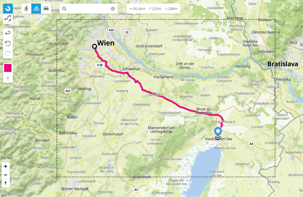
Use the editor to show directions
Our route editor offers more than just the ability to draw routes freehand. It features a wizard that magnetically snaps to existing roads, enabling you to create routes within seconds. This innovative tool not only showcases points of interest in the neighborhood or road network to illustrate reachability but also facilitates the inclusion of directions in real estate home flyers.
By incorporating directions into your flyers, you ensure that potential buyers have clear guidance on how to find you, enhancing their overall experience and reducing any potential confusion.
It is what you make of it
Crafting printable maps for publications involves more than just having the right geo-tools; it’s about leveraging your own designs and ideas. With Printmaps, you have complete flexibility, whether it’s choosing the type of cartography or selecting the features to include in your map.
But the customization doesn’t stop there. Once you’ve created and downloaded your map, the possibilities are endless. Want to enhance points of interest with additional details? Add your own logos, graphics, or text? Our maps are delivered in a layered PSD format, allowing you to modify every aspect, right down to individual points of interest.
Why not give our editor a try and discover how you can effortlessly transform your ideas into the perfect map tailored for publication?
Try Printmaps
Our map-editor lets you create printable maps worldwide in no time.
FAQ
Our pin tool allows you to use an array of different symbols to indicate the context of different locations you are trying to highlight. To add the pin, you can simply place it on the map by dragging it around and then you can edit the color, shape, and symbol of the pin to give the different locations on the map visual clarity.
A distinctive property marker, and a curated set of 4–8 audience-matched POIs (schools, transit, parks, grocery) most strongly influence buyer interest. Use simple, color-coded icons and concise labels so the property pin remains the visual anchor.
You can create an excel file that follows the layout of our spreadsheet batch-geocoder and then paste them in to create the pins quickly. Read this article if you want to know more.